I am a member of several trail and backpacking groups on Facebook and I was answering a question from an older female about how safe it was to hike solo in our local mountains. Someone in my local area who knows how much I blog about my trips recommended my blog as a good resource for the trails in the Bighorn Mountains (my back yard). However, despite my many trip reports there is very little on my blog that covers what I do to plan a solo hike, which is what I tend to do 90% of the time. This guide does NOT include planning for gear.
So I began thinking about what I take into consideration as a solo hiker in regards to my safety and trail planning. I wouldn’t say this is a comprehensive list but I think it’s a good place to get started:

Buy a map of the area and study it: Study the terrain, mileage, water sources and know your limitations. While I am ABLE to hike upwards of 15 miles a day I find it tough to do in mountainous terrain and I certainly don’t enjoy it; 15 miles on the flat is a different beast. I plan my daily miles in the mountains to be in the 10-12 mile region…if I do more, that’s great but I don’t plan on it. Water is heavy but knowing your water sources and carrying a good filter means you can carry less water. Lots of climbs and descents are going to slow you down; don’t over underestimate how much a 2500ft climb can take out of you and how much it will impact your mileage.
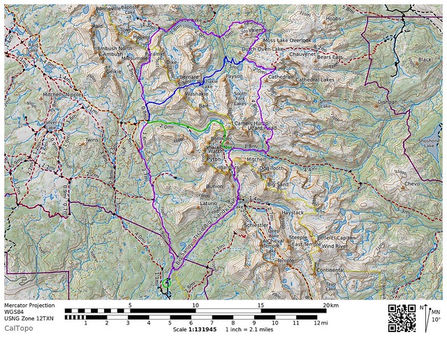
Plan your route: Start by knowing how many days you have and then multiply that by how many miles YOU can hike in a day safely. Once you know this you can work out a route that fits your hiking level and the time you have…it is better to be done a little early than be pushed for time and make a mistake, and I always find it nice to be done early and then have time for some relaxation and a beer. When you have a rough idea of the route and which trails you might want to take go check out CalTopo.com. CalTopo is a great tool for mapping out your specific trail if you don’t have a good map of the area; it is fairly intuitive and you can print out your own maps, and files can be exported to GPS. I use CalTopo when a good Trails Illustrated map isn’t available for the area I plan on hiking or when I don’t want to spend the money for a map on a lone trip to a single area.
A second layer of planning a route is to talk to locals; learn from others’ experiences what trail conditions will be like, how easy it is to navigate, whether there are any tough areas of particular concern. Almost every national forest, wilderness area or state or national park has a locals-run Facebook group dedicated to the trails in the area. The local Ranger District Office is often a pretty decent resource for this too.
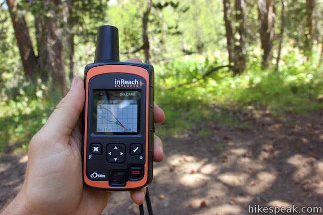
Safety Net: I do not have anyone at home to expect me back at a certain time so I work around that safety aspect in several ways. I carry a DeLorme InReach device so that I have SOS connective capabilities in the event of an emergency. However, there is always the possibility that in a fall I may lose consciousness or the device gets broken. I have a back up for this and leave my planned route (including the direction I plan on hiking) plus the CalTopo map file with three or more friends who I check in with twice daily. If I miss two or more check-ins they call out the cavalry. I make this easy by providing them with the Ranger District of the National Forest or BLM area I will be hiking on WITH their phone number AND the contact information for the Sheriff’s Office of the counties I will be hiking through. I chose to go with two missed check-ins and to check-in twice daily as that gives me a maximum of 24 hours before someone will be aware that something is wrong, but also because I may inadvertently miss one check-in or temporarily may not be able to get a signal out due to tree coverage etc. For those that DO have someone at home; always leave them a copy of your route and a time to expect you back…Aron Ralston learned the hard way of the consequences of not doing this.
Know Your Gear: While I don’t intend to cover gear choices here an important aspect of staying safe, especially when solo, is carrying decent gear and knowing how to use it and what its limits are. No matter the length or duration of my hike (whether day hike or week-long trip) I ALWAYS carry a water filter, food, shelter and a way to keep warm as well as my InReach. These things are non-negotiable. Appropriate clothing and footwear for the season and terrain should never be overlooked or assumed; no matter what anyone says a bikini and flip flops are never suitable for any excursion into the back country even if it is “just a mile”. But more than knowing your gear, having some knowledge in your head weighs nothing and can save your life, so if you can learn from others before you go, do so.
